
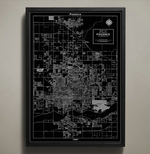
Map Print, PHOENIX
$29.00
Map Print, PHOENIX
————————————————————————
Vintage Map Print Sizes Available
18” x 24” $29
24” x 36” $63
36” x 48” $118
Frame not included.
© Copyright 2013 GeoArtShed. Artwork may not be reproduced or resold
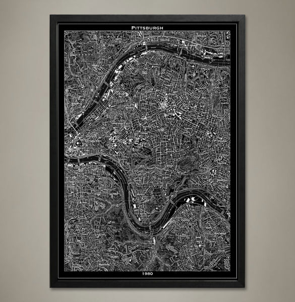
Map Print, PITTSBURGH
$29.00
Map print, Pittsburgh
Our Pittsburgh map print focuses on the eastern side of the city.
————————————————————————
Vintage Map Print Sizes Available
18” x 24” $29
24” x 36” $63
36” x 48” $118
Frame not included.
© Copyright 2013 GeoArtShed. Artwork may not be reproduced or resold
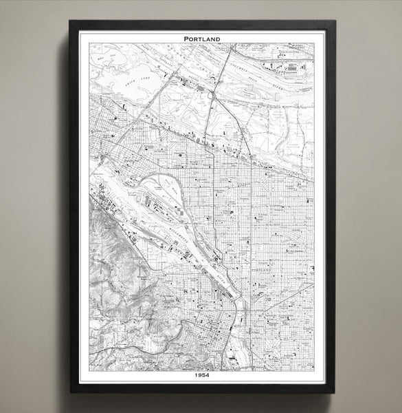
Map Print, PORTLAND
$29.00
Portland is a city of artists, dreamers and thinkers. This Portland map print poster not only shows its streets, parks, bridges and highways, it also shows the distinct divide of the Willamette River. Order this map in your choice of three different sizes; 18x24, 24x36 or 36x48 inches. Each print comes on archival that will last you for years to come.
————————————————————————
Vintage Map Print Sizes Available
18” x 24” $29
24” x 36” $63
36” x 48” $118
Frame not included.
© Copyright 2013 GeoArtShed. Artwork may not be reproduced or resold
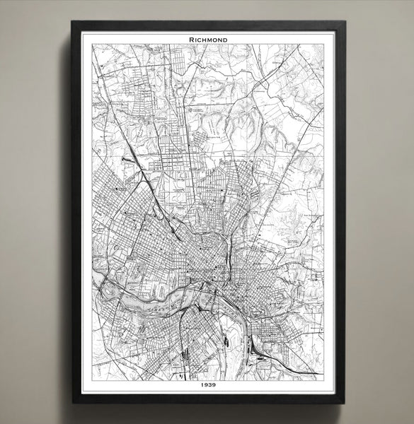
Map Print, RICHMOND
$29.00
This vintage style map print details the city of Richmond, Virginia as it stood in 1939. Richmond is the capital of the great state of Virginia and boasts Southern charm, a rich history, and picnic tables overflowing with ham biscuits, pimento cheese, and (of course) barbeque. This vintage map print is printed to your specifications in either a white or black scheme and features high quality cardstock and archival inks designed to last a lifetime.
The purchase of this listing is for one Richmond city map print with the following specifications and options:
Style: Map of Richmond, Virginia (Circa 1939)
Sizes available: 18 x 24, 24 x 36 or 36 x 48 inches
Colors available: Black or white
Materials: 100# premium card stock
Please note the purchase of this Richmond poster does not include a frame. Your map of Richmond poster will be mailed via USPS First Class and preserved in a durable shipping tube. If you would like to continue to shop for more map prints, map posters, or new graduate gifts and office decorations you may return to the GeoArtShed by clicking the following link:
http://www.geoartshed.com/collections/print-posters-city-maps
© Copyright 2013 GeoArtShed. Artwork may not be reproduced or resold.
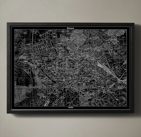
Map Print, ROME
$29.00
Today Rome is a modern urban city, but its long history has been beautifully preserved throughout its streets. Those streets, along with Rome's city blocks, squares, parks, tunnels and bridges are detailed in our 1855 Rome poster map. The Medieval, Renaissance and Baroque times shaped every square inch of Rome, and with our recreation of such an important map you too can admire the city's character. We print all of our poster maps on archival quality stock with a 1/2 inch border around the poster's edge for easy framing.
————————————————————————
Vintage Map Print Sizes Available
18” x 24” $29
24” x 36” $63
36” x 48” $118
Frame not included.
© Copyright 2013 GeoArtShed. Artwork may not be reproduced or resold

Map Print, SALT LAKE CITY
$29.00
Map Print, Salt Lake City
————————————————————————
Vintage Map Print Sizes Available
18” x 24” $29
24” x 36” $63
36” x 48” $118
Frame not included.
© Copyright 2013 GeoArtShed. Artwork may not be reproduced or resold
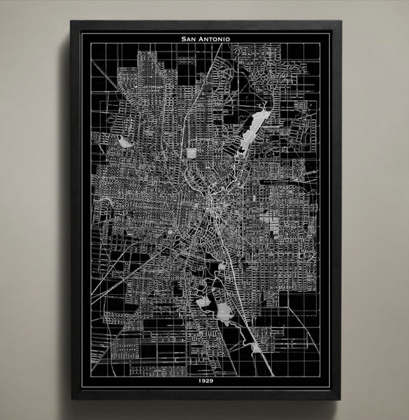
Map Print, SAN ANTONIO
$29.00
Each one of San Antonio's street names, tunnels, bridges, highways, parks and neighborhoods are clearly depicted in our San Antonio map print poster. Originally made in 1929, you can see the masterful artistry of its maker as clearly as if you were flying above the city yourself. Like all of our maps, this one is printed on quality paper that ensures it will last a lifetime. We also print our posters with an added 1/2 border for hassle free framing.
————————————————————————
Vintage Map Print Sizes Available
18” x 24” $29
24” x 36” $63
36” x 48” $118
Frame not included.
© Copyright 2013 GeoArtShed. Artwork may not be reproduced or resold
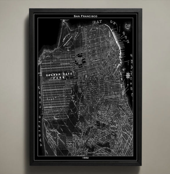
Map Print, SAN FRANCISCO
$29.00
There is a reason so many have left their hearts in San Francisco: It is a city that captures romance, culture, and diversity with unparalleled urban elegance. This San Francisco map print seeks to inspire you with a skeletal remembrance of the city in the late 1800s. As your fingers trace over the terrain, coastlines, and streets of yesteryear you will be transported to a time when San Francisco was young and ambitious but somehow still as full of life as it is today.
The purchase of this listing is for one map print of the city of San Francisco with the following specifications and options:
Style: Map of San Francisco, California (Circa 1892)
Sizes available: 18 x 24, 24 x 36 or 36 x 48 inches
Colors available: Black or white
Materials: 100# premium card stock
Your San Francisco print does not include a frame but will be mailed to you via USPS First Class in a durable shipping tube. You can return to the GeoArtShed shop home to find more map prints, vintage map reproductions, or map posters of a wide variety of cities by following this link:
http://www.geoartshed.com/collections/print-posters-city-maps
© Copyright 2013 GeoArtShed. Artwork may not be reproduced or resold.
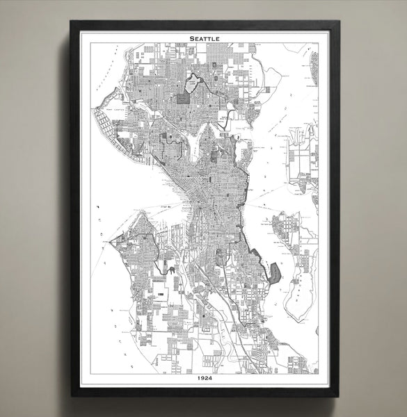
Map Print, SEATTLE
$29.00
Seattle, Washington has been known by many names including Jet City, Rain City, and the City of Goodwill. Inspire a touch of goodwill in your home or office when you display this delightfully vintage Seattle city map. This Seattle poster is expertly recreated from an accurate 1924 Seattle map and features high quality cardstock and premium archival ink in your choice of colors and sizes. This particular Seattle map print would be especially beloved by any University of Washington alumni or Seahawks fan.
The purchase of this listing is for one map print of the city of Seattle with the following specifications and options:
Style: Map of Seattle, Washington (Circa 1924)
Sizes available: 18 x 24, 24 x 36 or 36 x 48 inches
Colors available: Black or white
Materials: 100# premium card stock
Your Seattle print does not include a frame but will be mailed to you via USPS First Class in a durable shipping tube. You can return to the GeoArtShed shop home to find more map prints, map posters, or new graduate gifts and office decorations following this link:
http://www.geoartshed.com/collections/print-posters-city-maps
© Copyright 2013 GeoArtShed. Artwork may not be reproduced or resold.
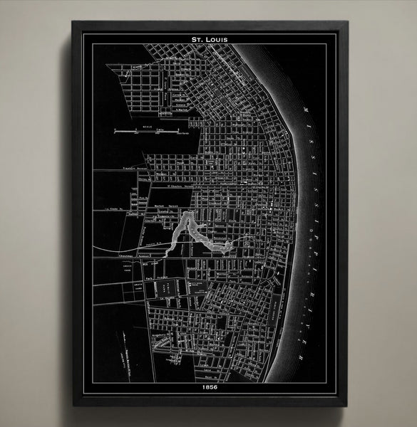
Map Print, ST. LOUIS
$29.00
This vintage 1856 St. Louis map details the city towards the end of its rapid growth between the years of 1840 and 1860. Within those two decades St. Louis grew from a quaint city of 20,000 to a bustling city of 160,000. Our St. Louis city map is printed on premium archival stock with a 1/2 inch border around the map's edges for easy framing.
————————————————————————
Vintage Map Print Sizes Available
18” x 24” $29
24” x 36” $63
36” x 48” $118
Frame not included.
© Copyright 2013 GeoArtShed. Artwork may not be reproduced or resold
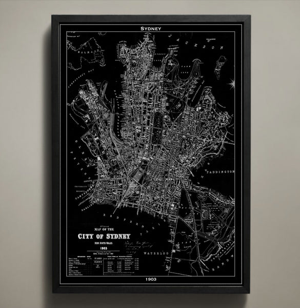
Map Print, SYDNEY
$29.00
The Sydney we know today looked much different in the early 1900s. The streets were unpaved, horse-drawn carriages crossed paths with the 1900s version of public transportation and even with its warm climate both men and women were modestly clothed from head to toe. In our 1903 map the city of Sydney and all of its streets, parks, bridges and squares are contrasted by its large harbor. You can order the Sydney map in several different sizes and printed on archival quality stock with a 1/2 inch border around the poster's edge for easy framing.
————————————————————————
Vintage Map Print Sizes Available
18” x 24” $29
24” x 36” $63
36” x 48” $118
Frame not included.
© Copyright 2013 GeoArtShed. Artwork may not be reproduced or resold
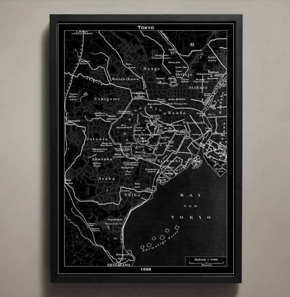
Map Print, TOKYO
$29.00
Today Tokyo is full of skyscrapers, busy streets and neon lights, but back in the 1890s it had an empty skyline, dirt roads and pink blooms that brought natural color to Japan's capital. This Tokyo map print poster is printed on premium archival stock with a 1/2 inch border around the poster's edge for easy framing. Own this distinct map in one of three sizes and in your choice of black or white.
————————————————————————
Vintage Map Print Sizes Available
18” x 24” $29
24” x 36” $63
36” x 48” $118
Frame not included.
© Copyright 2013 GeoArtShed. Artwork may not be reproduced or resold
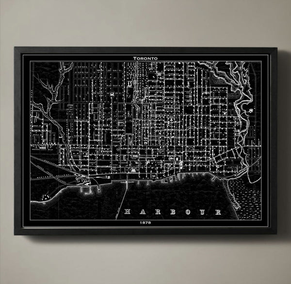
Map Print, TORONTO
$29.00
Toronto's skyline is distinct with its CN Tower rising into the sky far above the surrounding skyscrapers, but in 1878 the idea of erecting the world's tallest structure hadn't yet been a thought in anyone's mind. In 1878 when our map was originally sketched the town of Toronto was enjoying the newly built Union Station that connected the town to the Grand Trunk Railway and Northern Canada's railway. These new railroads, every bustling street and every port and dock of Toronto is captured in our map.
————————————————————————
Vintage Map Print Sizes Available
18” x 24” $29
24” x 36” $63
36” x 48” $118
Frame not included.
© Copyright 2013 GeoArtShed. Artwork may not be reproduced or resold
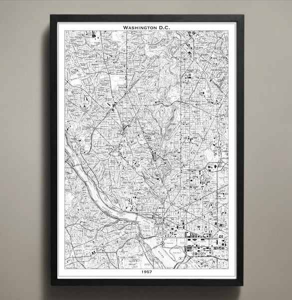
Map Print, WASHINGTON DC
$29.00
This Washington, DC map print poster mirrors the bustling, busy streets of the capitol in 1957 with amazing accuracy. It goes without saying that the history of Washington, DC is complex and staggering but what makes this particular map unique is that is a recreation of the cities infrastructure the same year that Martin Luther King made his “Give Us The Ballot” address winning over the hearts and minds of a generation previously uninspired. This DC poster would make a fantastic addition to any political enthusiasts’ home or office but is especially poignant for students studying civil engineering or civil liberties.
The purchase of this listing is for one map print of Washington, DC with the following specifications and options:
Style: Map of Washington, DC (Circa 1957)
Sizes available: 18 x 24, 24 x 36 or 36 x 48 inches
Colors available: Black or white
Materials: 100# premium card stock
Your DC print does not include a frame but will be mailed to you via USPS First Class in a durable shipping tube. You can return to the GeoArtShed shop home to find more map prints, map posters, or even typography wall art by following this link:
http://www.geoartshed.com/collections/print-posters-city-maps
© Copyright 2013 GeoArtShed. Artwork may not be reproduced or resold.
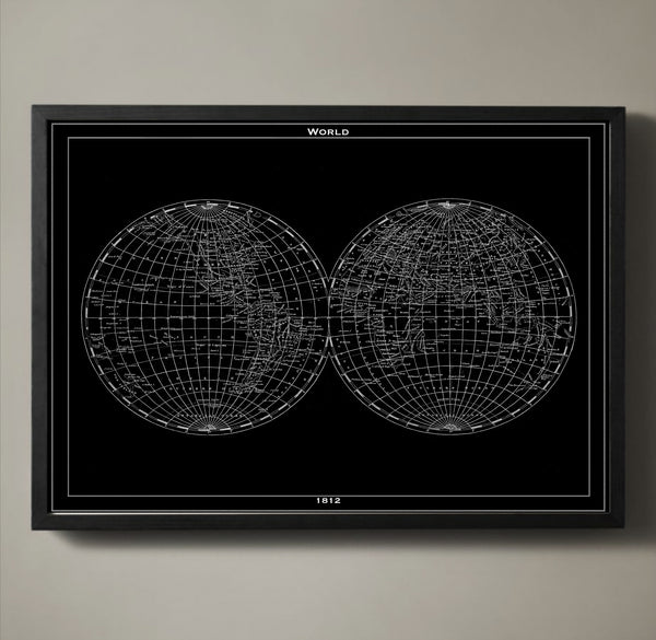
Map Print, WORLD
$29.00
A reproduction of a handmade map from 1812, our world map displays our entire globe in an eye-catching fashion. Each country and every ocean is accounted for, delicately labeled and available in either black or white. This vintage style world map is printed on premium archival stock with a 1/2 inch border around the poster's edge so that you can frame it with ease.
————————————————————————
Vintage Map Print Sizes Available
18” x 24” $29
24” x 36” $63
36” x 48” $118
Frame not included.
© Copyright 2013 GeoArtShed. Artwork may not be reproduced or resold
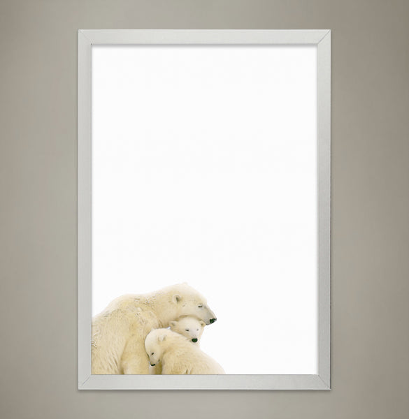
POLAR BEAR Family Print, Animal Print Nursery wall decor, Wall Art for Children's room, Baby Room Decor, Watercolor Animal Illustrations
$23.00
This print is of our watercolor illustration of two baby Polar Bears snuggling with their Mother that goes perfectly in any nursery or children's room. Place one of our prints by itself or group our wall art pieces together to brighten up your little one's walls. All of our animal wall art, printing and packaging is completed in-house.
Material Options
Archival Semimatte
Our Premium "Archival Semimatte" is acid free artist photo paper that will last a lifetime.
Canvas
Our Premium Canvas is extremely rich in detail and the colors look absolutely amazing. Like our Archival paper, our canvas is designed to last over 100 years.
Frames are not included
Your print will arrive ready to frame, wrapped in a plastic sleeve to protect your prints from the elements, rolled perfectly secure in a durable shipping tube.
© Copyright 2013 GeoArtShed. Artwork may not be reproduced or resold
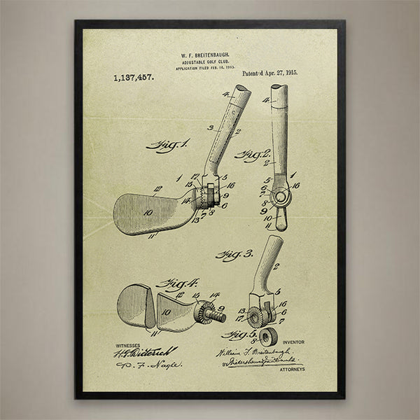
Unique Golf 1915-Adjustable Golf Club Patent
$24.00
Amazing, a 1915 design for one club does it all! If you love the game of Golf, this piece of Golf history is the perfect addition to your home or office decor. A true conversation piece that will add interest and impress your golfing buddies . All of our Golf Patent Prints are printed on Epson Premium Luster 260 photo stock using Epson Premium archival ink to ensure that you will have a beautiful print that will last a lifetime. Add this piece of Golf history to your home or office art collection today! Available in stained and sizes up to 36"x48".Frame not included.
© Copyright 2021 GeoArtShed. Artwork may not be reproduced or resold
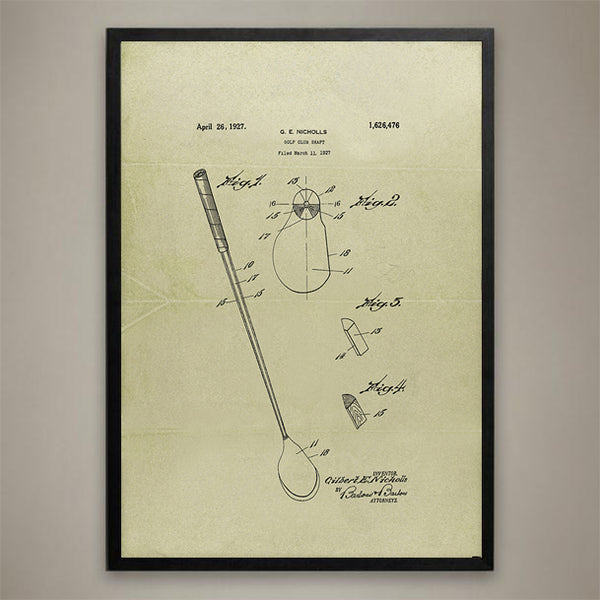
Vintage 1927 Golf Club Patent Drawing
$24.00
1927 Historical Patent Drawing of a Vintage Golf Club that will add interest to your decor and impress your golfing buddies . If you love the game of Golf, this piece of Golf history is the perfect addition to your home or office decor. All of our Golf Patent Prints are printed on Epson Premium 260 Paper using archival ink to ensure that you will have a beautiful print that will last a lifetime. Add this piece of Golf history to your home or office art collection today! Available in stained and sizes up to 36"x48".Frame not included.
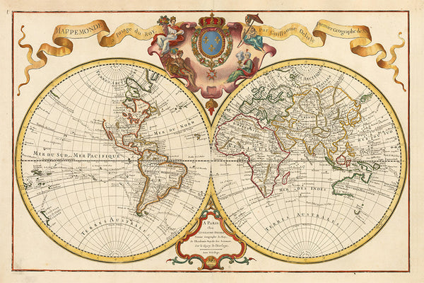
World Map 1720 | Double Hemisphere Map | Delisle de L’lsle Map |
$55.00
This custom crafted and retouched 24" x 36" reproduction of Delisle’s famous double hemisphere map of the world circa 1720 shows amazing detail of the entire known world at the time. The crowned cartouche at the top of the map shows four human figures, representing the four continents, in exquisite detail and beautiful colors. The Ocean and land areas show the navigational routes of famous explorers.Guillaume Delisle, also spelled Guillaume de l'Isle, 1675 -1726, was a French cartographer known for his popular and accurate maps of Europe and the newly explored Americas.
This amazing map will add style and beauty to any home or office décor.